
India Reaches a Historic Milestone in Aviation with First GAGAN-Guided Jet Landing. India's homegrown GAGAN (GPS-Aided GEO-Augmented Navigation) system just guided a narrow body aircraft to a precise landing .
An IndiGo Airbus A320 on 27 June 2025 completed India's first satellite-guided commercial jet landing using the indigenously developed GAGAN navigation system.
Airports Authority of India (AAI) aims 40+ LPV-enabled airports by year-end, it signals a structural shift in how the country's rapidly expanding aviation network handles precision landings.
Unlike the conventional Instrument Landing System (ILS), which relies on specialised radio transmitters physically installed at each airport, the IndiGo A320 executed a Localiser Performance with Vertical Guidance (LPV) approach, guided entirely by satellite signals.
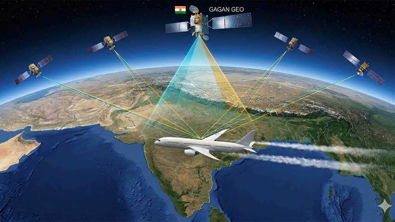
GAGAN (GPS Aided GEO Augmented Navigation) is a Space-Based Augmentation System (SBAS) that improves the accuracy, integrity, and availability of standard GPS signals. Developed by the Airports Authority of India (AAI) and ISRO, it refines raw GPS data to pinpoint locations within 1.5 meters.
Standard GPS only offers an accuracy of 5 to 10 meters, which isn't safe enough for commercial aircraft landings. GAGAN bridges this gap by adding vertical and horizontal guidance, allowing pilots to perform precision approaches at small regional airports without the need for expensive physical Instrument Landing Systems (ILS).
GAGAN works through a continuous four-step pipeline of observation, correction, and broadcast:
Observation (Ground Stations): A network of 15 precisely surveyed INdian Reference Stations (INRES) scattered across India continuously tracks signals from GPS satellites.
Calculation (Master Control Centers): These ground stations forward their data to two Indian Master Control Centers (INMCC). The control centers compare the received GPS data with the known, fixed locations of the reference stations to calculate errors caused by atmospheric disturbances (like ionospheric delays), satellite clock drift, and orbit deviations.
Uplink (Land Stations): Once the corrections and integrity data are computed, they are sent to Indian Land Uplink Stations (INLUS). These stations beam the data up to Geostationary Earth Orbit (GEO) satellites (such as GSAT-8, GSAT-10, and GSAT-15).
Broadcast & Reception (User Segments): The GEO satellites broadcast the correction messages back down to Earth on the same frequencies used by standard GPS receivers. Any SBAS-compatible GPS receiver can read these signals, apply the corrections, and calculate highly precise 3D positioning coordinates.
India's geographical location presents a particular challenge for GPS-based aviation. The country lies beneath the equatorial ionisation anomaly, a region where atmospheric disturbances can cause significant and unpredictable distortions in GPS signals. Standard GPS cannot guarantee the integrity required for aircraft approaches in such conditions.
Not only the precision part of it, GAGAN also benefits airports that currently lack ILS infrastructure, a significant portion of India's expanding airport network. It also serves as a backup when ILS is unavailable due to maintenance, or when flights are diverted to alternate airports without ILS capability.